Mapping the Heritage of Glencolmcille Parish – Glencolmcille, Co. Donegal
 Selected as an exemplar case study by DCU in partnership with .IE
Funding by .IE
Funding awarded: €9,000
Maturity: Pilot
Timeframe: Started 2021
Dermot Diamond
Project Manager
(074) 973 0248
oifig@oideasgael.ie
Caitríona Nic Seoin,
oifiglcpg@gmail.com
+353 83 448 1999

Who:
Oideas Gael, DCU School of History and Geography, and Béal an Phobail.
Glencolmcille is situated on the Slieve League Peninsula at the south-west point of Donegal – an area starting to be known as the Donegal Highlands and part of the Wild Atlantic Way coastal drive. Glencolmcille is a small town based in the Donegal Gaeltacht with over 200 residents. Like many rural Gaeltacht communities, Glencolmcille faces challenges in maintaining, retaining, and growing the Irish speaking population and an associated rich cultural heritage. The history and heritage are part of what makes the area unique and attractive to visitors but thus far has existed either orally or in academic institutions outside the locality. As the local geography and infrastructure limit economic development options such as manufacturing, Gaeltacht communities like Glencolmcille are increasingly turning towards tourism for job creation. Therefore, open access digital repositories offer the area a method to make knowledge collected more accessible to a wider audience.
The information gathered is of general interest to the local community, as it embodies a wealth of local knowledge and history, but also holds significant value in terms of education and tourism as there is a broad interest nowadays in domains where Ireland’s linguistic, social and ecological heritages intersect.
Objectives:
- To preserve and promote place name heritage.
- To produce a living and inclusive digital repository of Glencolmcille’s cultural heritage that is easily accessible to everyone at home and abroad.
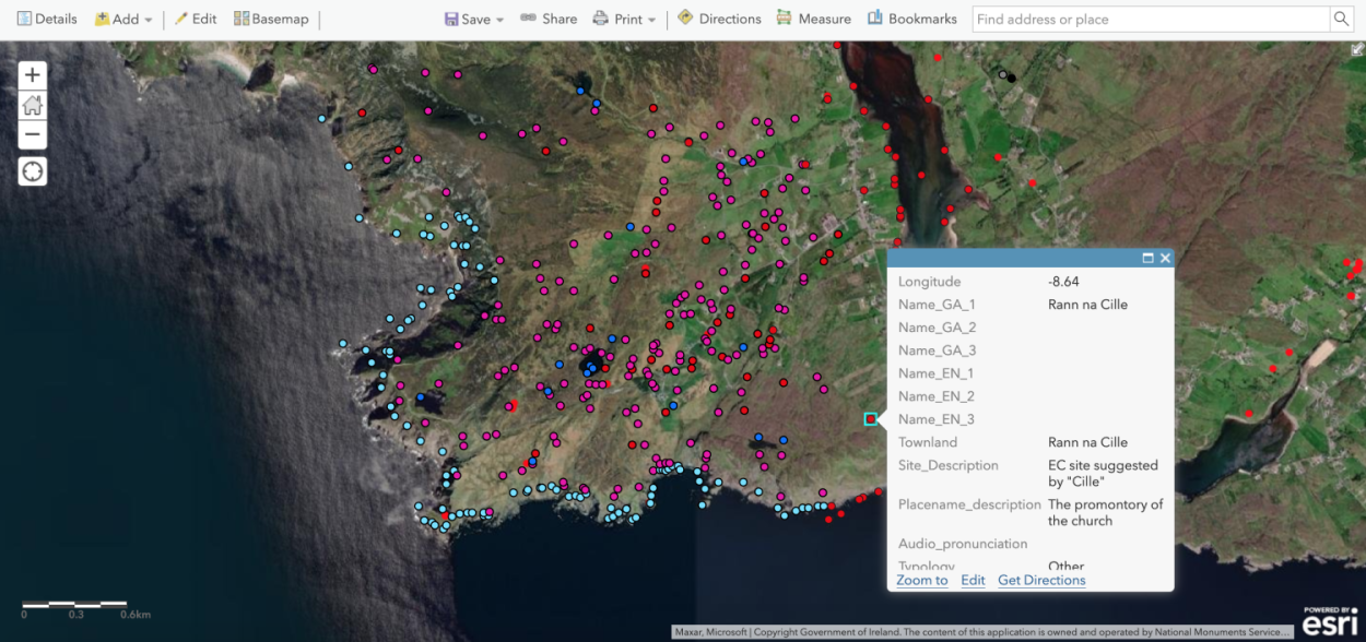
- To plot the place names in the ArcGIS mapping platform and the associated lore.
- To create reusable digital resources that make the local heritage and culture accessible and engaging to locals and visitors.
What:
The project Mapping the Heritage of Glencolmcille Parish (Logainmneacha Pharóiste Ghleann Cholm Cille) collects the names and folklore of the about 3000 fields, crags, rocks, streams, hollows, and many other features of the landscape in the parish of Glencolmcille, Co. Donegal. The data is collected from county databases, the National Folklore Collection, the National Library of Ireland, as well as from local knowledge provided by a list of local informants and residents who participated in the research. This data is then entered into an interactive digital map of minor place names in the Glencolmcille parish. The knowledge gathered for the project is accessible to everyone, searchable on the online interactive map, and open to corrections and further suggestions from the community.
Why:
The project aims to preserve and highlight the valuable heritage within the community that might otherwise be lost. Many names and their locations, as well as the stories that go along with them, are only known by a few people and shared orally. These place names outline the history and folklore of the region, the natural coastal and marine environments, as well as the lives and beliefs of many of those who lived there. This project is a focal point for intergenerational learning, community involvement and cooperation, promotion of the Irish language, and a valuable asset for tourism in the region.
Scale:
The current project is limited to just one parish in West Donegal, however if successful and promoted, it could produce a template that could be used by other communities and localities throughout the country to capture the heritage-based knowledge that is unique to Ireland.
Technologies:
Logainmneacha Pharóiste Ghleann Cholm Cille uses the ArcGIS mapping platform, drone-assisted 3D photogrammetry, standard audio recording and videography techniques.
Lessons Learned:
This project is ongoing and was always intended to give community members a chance to get involved and share their feedback. So far, it has achieved a significant reach, with many items shared by over 10,000 people through social media and attracting media coverage.
Two factors were crucial to making the project more successful:
- bringing in outside expertise allowed the community to maximise the advantages offered by the ArcGIS platform
- getting funding to employ dedicated on-the-ground field workers who were trained to collect, verify and digital transcribe heritage data for approx. 12 weeks total each year. This provided momentum to the voluntary work that continues outside the funding window.
One challenge during COVID was in gathering information from people within the community. While many people have already got involved, the project aims to reach further people in the community by:
- Hosting public meetings in various venues throughout the parish.
- Making packages available to those who would like to collect place names themselves.
- Working in collaboration with local schools.

Written by Dr. Jennifer Kennedy, The Irish Institute of Digital Business, Dublin City University.